Regional & local government / Public health
Translating community perceptions of health and place into local planning policy and monitoring frameworks
By Helen Pineo, Simon Bevan, Andrew Ruck, Dr Doug McNab and Clizia Deidda | 08 Feb 2018 | 0
This paper describes research looking at three key health themes – social interaction and isolation, obesity and inactivity, and health service provision and access – and which focused on two key regeneration areas.
Authors of scientific paper:

Abstract
Framework: Southwark and Lambeth Councils received funding from Guy’s & St Thomas’ Charity to use intensive quantitative and qualitative social research methods to generate robust, location-specific findings across three key health themes: social interaction and isolation, obesity and inactivity, and health service provision/access. The research focused on two key regeneration areas where significant growth is planned. The councils commissioned an academic literature review to inform the research methods. The research was undertaken externally and involved: face-to-face in-home surveys (453 residents); two resident workshops on social isolation; one focus group with mothers on social interaction; six focus groups with school children on healthy eating and walking; one focus group about health services; and five in-depth interviews with primary healthcare professionals.
Practical application: The social research findings were summarised in a final report and presented to council staff (planning and public health) and the project steering group (external stakeholders covering policy and academe). Key findings included residents’ perceptions of: lack of safety in certain areas at night; traffic safety concerns; need for local affordable amenities, including leisure facilities; issues with affordability of locally available fresh food and high number of fast-food outlets; provision of green space; and interest in a community facility combining health services with other offers, such as leisure or training. Several specific built environment characteristics were highlighted by participants as impacting physical activity and social interaction.
Outcomes: This mixed-methods research project facilitated a far more representative and thorough analysis of health and place than can be achieved through typical community engagement activities. Participatory mapping was identified in the literature review, and was included in some focus groups. However, the maps were not meaningfully annotated and, as a result, some of the research findings were difficult to contextualise spatially and transfer to policy. This was a key lesson learned. It was also noted that interview questions should allow for regional or national benchmarking where possible (using published survey data).
Implications: The residents’ perceptions have been used to inform a review of local planning policies, including a site-specific area action plan and borough-wide policies. This new local knowledge will also inform the selection of indicators to monitor the success of local policies in improving the built environment for health over time. This work is ongoing and may include exposure-based indicators (such as access to green space) and effect-based indicators (such as prevalence of obesity).
Keywords
There are many aspects of the physical urban environment that can impact residents’ health and wellbeing, both positively and negatively. Transport systems, for example, can support residents to achieve the recommended level of physical activity; they can also, however, create harmful air pollutants. In recognition of the relationship between the built environment and health, Southwark’s planning department worked with public health colleagues in the council and in the neighbouring borough of Lambeth to explore residents’ perceptions of health and place in areas with significant planned regeneration. The project was funded by Guy’s and St Thomas’s Charity. This paper outlines the process and findings of the local research project and describes how the results are being used by Southwark Council to inform planning policy for the borough and, specifically, the Old Kent Road Opportunity Area.
Background
Southwark is a London borough located along the south side of the River Thames with excellent access to the jobs and amenities of the city centre. Its population of 309,000 people is young and diverse, with almost half (45 per cent) of the borough’s residents from a non-white background.1
Although the borough is ranked the 12th most deprived in London (23rd in England), the council covers some of London’s most expensive property markets along the south bank of the river and is characterised by pockets of extreme wealth and deprivation.1 Inequalities and deprivation contribute to some of the residents’ primary health challenges, yet Southwark’s major employers, good schools and community amenities make it a prime candidate to support healthy urban living.
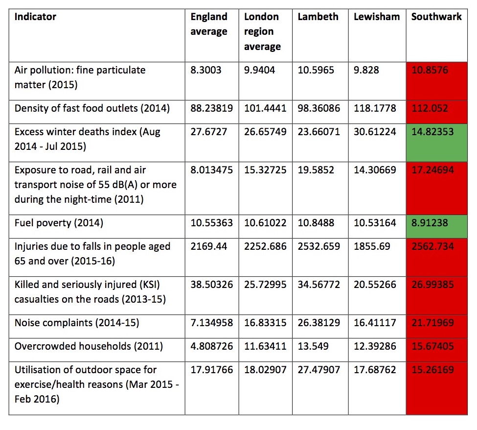
There are some positive healthy behaviours related to the built environment in Southwark; for example, residents walk and cycle more than their London peers.2,3 There are also some key challenges associated with the borough’s environment. The data in table 1 show how Southwark compares against its neighbouring boroughs, London and England in several key factors related to health and the built environment. Notably, Southwark has lower rates of excess winter deaths and fuel poverty than its London peers and the England average. There are, however, many areas that require improvement such as air pollution, overcrowding, and use of outdoor space for health and exercise.
Table 1: Comparison of natural and built environment indicators for Southwark, its neighbouring boroughs, London region and England.
In preparing for the research project, colleagues in Southwark and Lambeth worked across planning and public health departments to select three key health issues (and related areas of enquiry) that could be explored through the research based on local priorities (figure 1):
- social interaction and isolation;
- obesity (physical activity and healthy eating); and
- health service provision/access (particularly integrated health and related services).
These issues reflect known health and urban environment challenges in the boroughs. More than half of adults (55.3 per cent) in Southwark are overweight or obese.4 Children in Southwark have some of the highest levels of excess weight in England with 42.1 per cent of 11-year-olds currently overweight or obese.4 In deprived parts of the borough, children are 120-per-cent more likely to be obese than children from affluent areas.4 Physical activity and healthy eating were two areas with obvious links to the built environment to explore in relation to obesity.
Social isolation was raised as a key concern by public health and adult social services colleagues in Southwark. Particularly vulnerable groups were identified as residents who are disabled or living with chronic illnesses, the elderly, and mothers with young children. Officers had identified that faith groups may play an important role in providing opportunity for social interaction.
Health service access received attention owing to the number of planned new homes in Southwark. Significant levels of regeneration proposed in the area could offer the opportunity to design modern services from scratch, with few legacy constraints. Integration of health and social care were of interest and, potentially, other public services such as welfare, education and affordable housing. 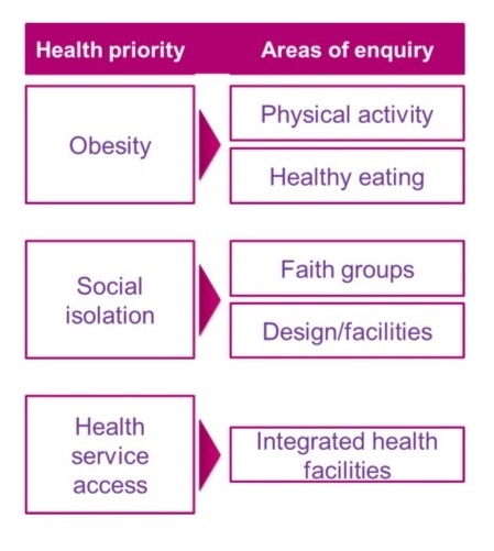
The aim of this project was to use quantitative and qualitative social research to generate robust, location-specific findings to inform development of planning policies and regeneration strategies that better address key impacts of the local built environment on health outcomes and health inequality.
Study area
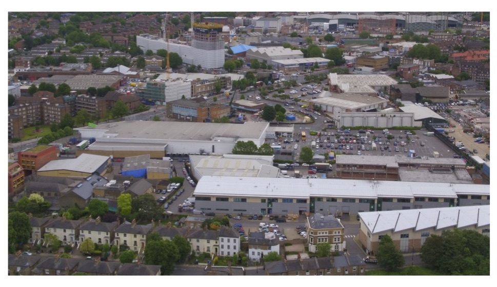
The Old Kent Road Opportunity Area is designated for large-scale regeneration. The emerging Area Action Plan outlines the significant transformation envisaged for this area, including: 20,000 new homes, space for 10,000 additional jobs and associated improvements to services and the local area (such as new parks, new tube stations, and new schools). The area is currently characterised by light industry, large warehouses, and big box retail along the Old Kent Road (see figure 2). Surrounding these are residential areas that are generally in good condition and will not be demolished. Over the next 20 years, new housing, employment space, transport infrastructure, and other facilities will transform this area into a densely populated urban community.
Methods
The research involved an initial literature review, followed by quantitative and qualitative social research methods. The literature review covered three areas:
- evidence demonstrating the urban environment impact on the three key health themes;
- existing best practice in relation to social research about health and place; and
- examples of international planning and regeneration policies/activities that address health and wellbeing objectives.
 The review methods involved searching bibliographic databases and the internet using search terms related to the three key health themes, and topics linked to planning, regeneration and the built environment. The review was completed by BRE and a summary version has been published.5
The literature review informed the approaches used in the social research, carried out by Ipsos Mori. Participatory mapping, for example, was identified as a useful method to engage local residents in discussions about health and place. This was used in some of the focus groups. The detailed social research methods are described in a separate report by Ipsos Mori.6 A total of 352 residents were surveyed and six focus groups were held with particular population groups (for example, mothers, school children and healthcare professionals) focused on the different health topics identified by Southwark Council.
The findings from the literature review and social research were then combined with the council’s existing evidence to inform the development of ‘A plan for a healthy Old Kent Road’. The emerging planning policy for Old Kent Road and the New Southwark Plan were both reviewed to determine the extent to which they support health and wellbeing objectives. Officers worked across council departments with support from a BRE employee on temporary secondment to interpret the findings, review policy, and identify actions to improve health (and health-related behaviours) through the regeneration of Old Kent Road. In addition, officers reviewed potential monitoring indicators to gauge the success of policies in improving local health and wellbeing through the built environment over time.
Results of social results
The full results are described in the Ipsos Mori report, published on the council’s website.6 Many of the key findings were not a surprise to those working in the planning and public health departments; for example, staff are aware that Old Kent Road is not a pedestrian-friendly environment and that steps will need to be taken to improve this corridor to encourage walking and cycling.
But there were also some interesting findings that provided new information for the local authority, for example:
- Only 46 per cent of surveyed residents in Old Kent Road (and the nearby area) reported meeting the recommended aim of 30 minutes of at least moderate physical activity on five or more days per week, which is lower than the Southwark, London and England averages (59.7 per cent, 57.8 per cent and 57 per cent, respectively).2,6
- A greater portion of people in Old Kent Road reported feeling a sense of belonging to their local community (67 per cent) than London-wide (60 per cent) or national averages (63 per cent).6
- 42 per cent of those surveyed agreed that it’s easier to buy food from a takeaway than it is to buy fresh, healthy food. Southwark has 395 takeaway shops, roughly 128 per 100,000 people,i compared to approximately 108 per 100,000 in the Old Kent Road area.ii In the focus groups with school children, residents perceived there to be too many fast-food takeaways, particularly near schools.6
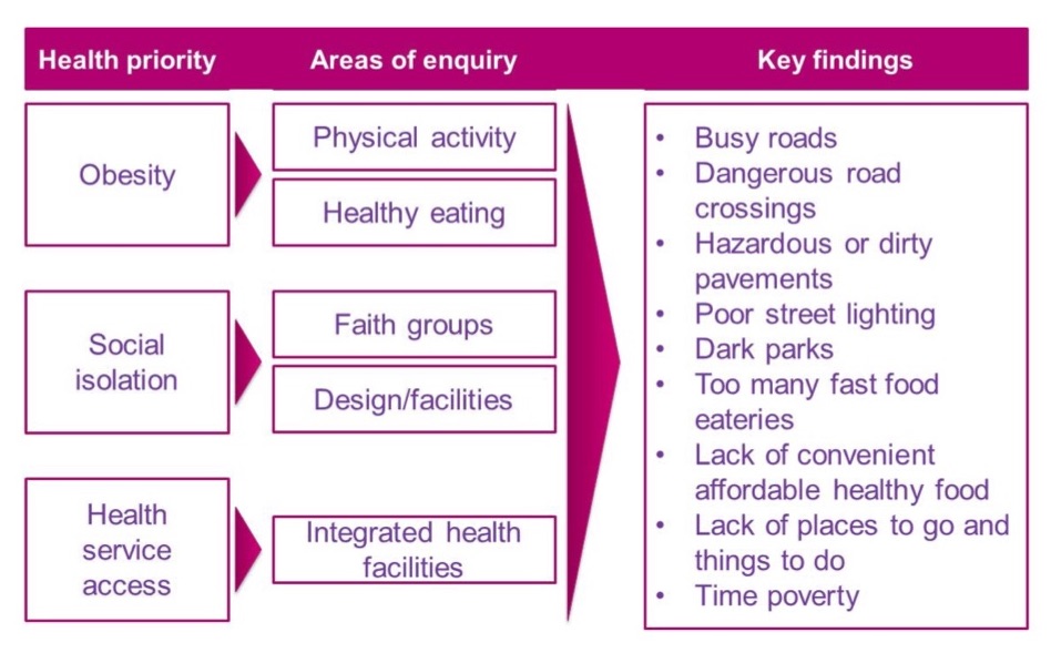
Figure 2 summarises the key findings from the social research. These findings cut across all three health priority themes.
 Planning’s response to the research findings
The planning department wanted to use this research project to go beyond the standard planning policy consultation approach, using focused social research to gather better data on how communities in or near regeneration areas live and what they need to live happy, healthy lives. This information is now being used to inform council policy.
Planning has many tools that can be used to support the creation and management of healthy urban environments. The National Planning Policy Framework makes many references to supporting the creation of healthy communities and a number of its policies relate to health (for example, sustainable transport, housing provision and good design). The London Plan Policy 3.2 explicitly considers health and health inequalities, encouraging the use of health impact assessments to evaluate how major development will impact health and wellbeing.
Local planning policy, including local plans, area action plans, neighbourhood plans, and supplementary planning documents, may all contain specific policies to encourage or require good design for health and wellbeing. This could be through policies limiting the location of hot food takeaways near schools or supporting active transport, for example. In Southwark, these findings will be used as part of the evidence base to inform the Old Kent Road Area Action Plan and the New Southwark Plan. Specifically, Southwark’s staff are working on ‘A plan for a healthy Old Kent Road’ to incorporate the social research findings into local planning policy and activities.
‘A plan for a healthy Old Kent Road’ builds on international best practice – for example, Los Angeles’ ‘Plan for a healthy Los Angeles’ and New York’s ‘Take care New York 2020’.7,8 It consolidates key findings from the local evidence and identifies actions that may occur through new planning policy, developer contributions or other council activities. It will serve as an evidence base document giving greater weight to health priorities in planning decisions, as well as setting out a wider programme of action.
The draft plan includes seven initial goals that are currently being further developed to improve health and wellbeing through the regeneration of Old Kent Road:
Goal 1: Current residents in and near Old Kent Road benefit from the new affordable housing and improved conditions in existing properties provided by the regeneration of the area.
Goal 2: Residents of all ages and abilities feel that walking and cycling are a safe, convenient and pleasurable activity for commuting, leisure and daily travel needs.
Goal 3: The design and management of new buildings in the Old Kent Road minimise residents’ exposure to harmful air pollutants indoors and outdoors.
Goal 4: Residents feel that there is sufficient access to healthy affordable food in the area and that the healthier choice is the easier choice.
Goal 5: Residents of all ages feel that there are affordable places to meet throughout the seasons.
Goal 6: New health facilities are integrated with other community services.
Goal 7: Residents’ mental health and wellbeing are improved by access to more and better green spaces
Next steps
Councillors have been involved in this project from the outset and are supportive of the proposed ‘A plan for a healthy Old Kent Road’. Departments across the council have been exploring how to take a more systematic approach to social regeneration in Southwark – advocating for residents in the development process and making their wellbeing a primary goal. The council will engage further with residents, local businesses and developers alongside the emerging area action plan, with the objective of making ‘A plan for a healthy Old Kent Road’ an exemplar of social regeneration.
Lessons learned
The literature review that was undertaken in the early part of this project showed that a mixed-methods research approach is most appropriate to integrate a range of perspectives, and provides a more representative and thorough analysis of health and place than can be achieved through typical community engagement activities.
With hindsight, there are some lessons to be learned about the selected methods that could help other local authorities when seeking to commission this type of research in the future. Participatory mapping was identified in the literature review as an effective way to associate residents’ concerns with specific places to inform local planning and regeneration processes. It can be effective for all age groups and combined with images taken by residents. At the council’s request, this was included in some focus groups.
The maps, however, were not meaningfully annotated and, as a result, some of the research findings were difficult to contextualise spatially and transfer to policy. This may have been due to a lack of knowledge from the researchers about the local area or how to use this particular research method. Furthermore, officers noted that the survey questions and focus group discussions were most useful when they could be compared with data about perceptions or behaviour at larger scales (Southwark, London and England). Not all of the questions allowed for this benchmarking and this limited the usability of such data because it wasn’t clear whether the responses were indicative of below average, normal or above average performance.
Conclusion
This project has provided officers in Southwark Council with location-specific data related to health and place and will support the creation of a new ‘Plan for a healthy Old Kent Road’ to elevate the importance of the health and wellbeing impact of planning activities. Overall, residents are likely to benefit from the integration of this evidence into the local authority’s strategies, polices and regeneration activities in Old Kent Road.
Looking at the regeneration project more widely, there are several challenges associated with incorporating health and wellbeing as a key objective to deliver through planning. Planning is tasked with bringing about sustainable development – placing an equal value on social, environmental and economic goals. This, however, usually involves some compromises. Not every development can provide everything that the council wants in terms of affordable housing, cash contributions, and facilities on site.
Regeneration can be managed with the interests of local residents, however, there will be some effects that the local authority cannot completely control. Residents who are tenants in the private rented sector are one group who may not be able to stay in the area, as rents are likely to rise after regeneration. The local authority can try to mitigate this by providing more affordable housing so that those tenants can move into affordable accommodation locally.
Density levels will inevitably be increased in the opportunity area (OA). The shortage of affordable housing in central London requires councils to build more housing on available land. If this is managed well, through high-quality urban design, there can be benefits from greater levels of density. In the case of Old Kent Road, higher densities will support new tube stations. There can, however, be disadvantages to higher density. If space, noise mitigation and privacy aren’t provided, higher levels of density can lead to challenges for health and wellbeing.
Authors
Helen Pineo is associate director – cities at BRE, a Chartered member of the Royal Town Planning Institute, and, in 2017, was seconded to Southwark Council’s Planning Department. Andrew Ruck is planning policy officer and Simon Bevan is director of planning at the council. Dr Doug McNab is a former member of the council’s Planning Department and Clizia Deidda is public health policy officer at the council.
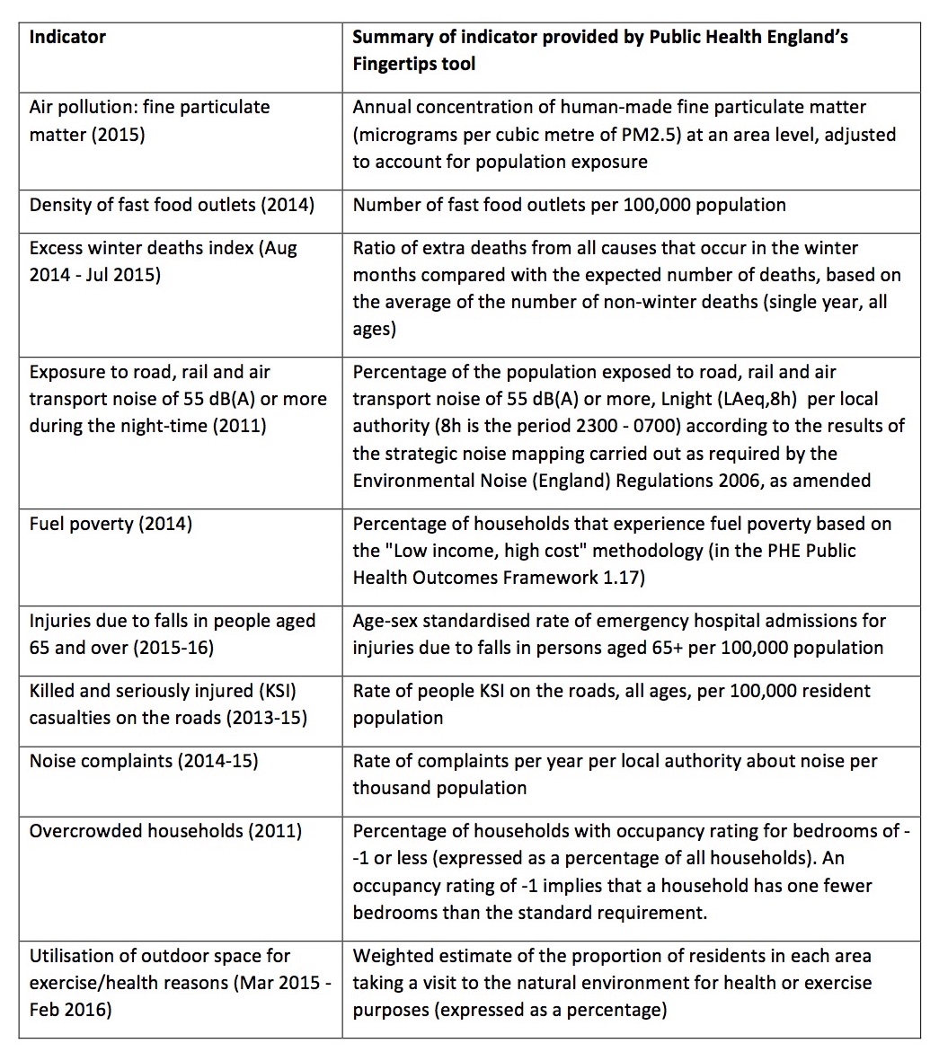
Appendix 1: Indicator definitions
Funding
The social research was funded by Guy’s and St Thomas’s Charity. The BRE Trust provided funding for a staff secondment from BRE to Southwark Council (HP) to support the integration of research findings into planning policy.
References
- Personal perspectives on urban health and wellbeing [Internet]. Guy’s and St Thomas’ Charity; 2017. Available from: https://www.gsttcharity.org.uk/get-involved/knowledge-hub/personal-perspectives-urban-health
- Public Health England. Public health profiles [Internet]. [cited 2017 Aug 17]. Available from: https://fingertips.phe.org.uk/
- Active travel in Southwark 2017: joint strategic needs assessment. Southwark Council; 2017.
- Annual report of the director of public health 2016. London: Southwark Council; 2017.
- Pineo H. Healthy planning and regeneration: innovations in community engagement, policy and monitoring. Building Research Establishment (BRE); 2017.
- The impact of planning policy on health outcomes and health inequalities in Southwark and Lambeth. Ipsos MORI Social Research Institute; 2017.
- Los Angeles Department of Planning. Plan for a healthy Los Angeles: a health and wellness element of the general plan. Los Angeles Department of Planning; 2015.
- Take care New York 2020 [Internet]. New York City Health Department; 2015 [cited 2017 Sep 21]. Available from: https://www1.nyc.gov/site/doh/health/neighborhood-health/take-care-new-york-2020.page
Footnotes
i HP calculated this based on the 2017 figures from the FEAT tool – http://www.feat-tool.org.uk/map/ – and an estimated 308,901 population in Southwark (ONS Mid-Year 2015 estimates). The PHE figure in the Ipsos Mori report is old.
Organisations involved